AWIS 10-Day Weather Report

— Written By
en Español / em Português
Español

El inglés es el idioma de control de esta página. En la medida en que haya algún conflicto entre la traducción al inglés y la traducción, el inglés prevalece.

Al hacer clic en el enlace de traducción se activa un servicio de traducción gratuito para convertir la página al español. Al igual que con cualquier traducción por Internet, la conversión no es sensible al contexto y puede que no traduzca el texto en su significado original. NC State Extension no garantiza la exactitud del texto traducido. Por favor, tenga en cuenta que algunas aplicaciones y/o servicios pueden no funcionar como se espera cuando se traducen.


Português

Inglês é o idioma de controle desta página. Na medida que haja algum conflito entre o texto original em Inglês e a tradução, o Inglês prevalece.

Ao clicar no link de tradução, um serviço gratuito de tradução será ativado para converter a página para o Português. Como em qualquer tradução pela internet, a conversão não é sensivel ao contexto e pode não ocorrer a tradução para o significado orginal. O serviço de Extensão da Carolina do Norte (NC State Extension) não garante a exatidão do texto traduzido. Por favor, observe que algumas funções ou serviços podem não funcionar como esperado após a tradução.


English

English is the controlling language of this page. To the extent there is any conflict between the English text and the translation, English controls.

Clicking on the translation link activates a free translation service to convert the page to Spanish. As with any Internet translation, the conversion is not context-sensitive and may not translate the text to its original meaning. NC State Extension does not guarantee the accuracy of the translated text. Please note that some applications and/or services may not function as expected when translated.

Collapse ▲

Dear strawberry grower community,

the 2018/19 season already brought a lot of rain and warm weather. The last few weeks it was advisable most of the time not use covers in NC, simply because it could lead to early crop enhancement and grey-mold outbreaks. Sacrificing bloom was often better advice than trying to keep them alive.

However, that will change now. We are entering the time of cold protection and sure enough, the next cold events are predicted for early next week (see Figure 1). At the same time, as if it wouldn’t be wet enough already, there will be higher chances of rain and snow over the coming days, starting tonight!

While minimum temperatures over the weekend are predicted to in the upper 30s still and there are no reasons to worry, the temperatures are predicted to drop well into the 20s early next week. The first cold night will be the night from Monday to Tuesday!

We advise using row covers latest on Monday and test your sprinkler systems over the weekend to have it ready in case you will need it.

1.) Minimum Temperatures for the next 5 days:

Friday weather graphic

Saturday weather graphic

Sunday weather graphicMonday weather graphicTuesday weather graphicWednesday weather graphic

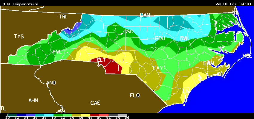
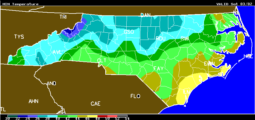
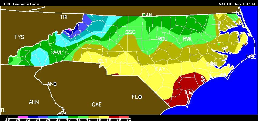
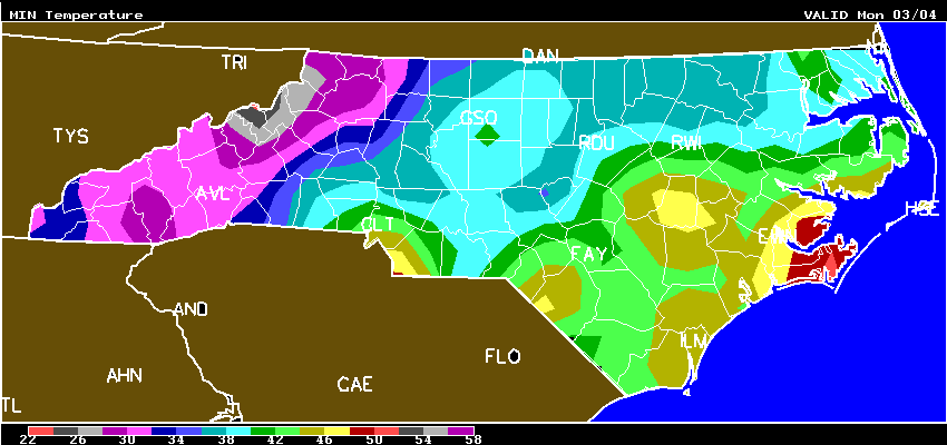
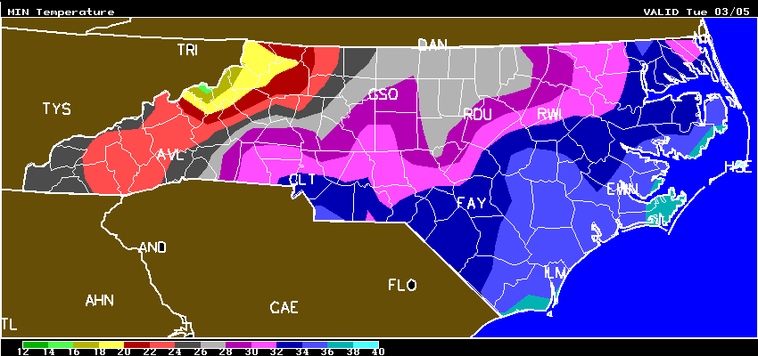
Figure 1: Minimum Temperatures for NC from Friday (3/1/2019) to Wednesday (3/6/2019).

2.) Rain/Snow:

Rain and snow graphic

Saturday rain graphic Sunday rain graphicMonday rain graphicTuesday rain graphic

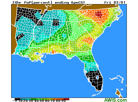
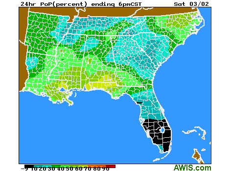
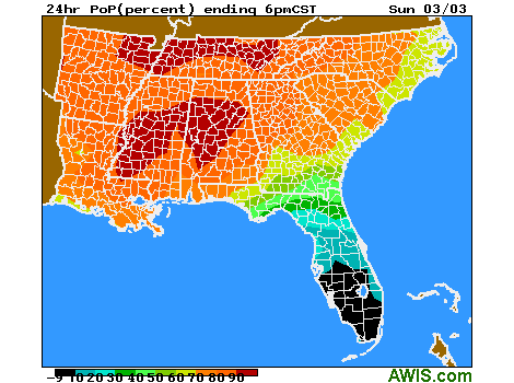
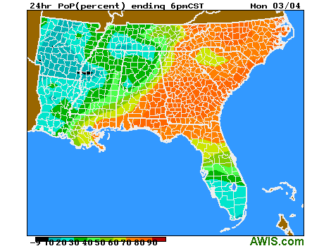
Figure 2: Likelihood of Precipitation for the coming days (Friday 3/1/2019 – Tuesday, 3/5/2019).

Statewide HOURLY 10-day forecasts:

North Carolina:

FORECASTS ARE AVAILABLE FOR THESE LOCATIONS:
Ahoskie-Tri-Cou Albemarle_AP Andrews Asheboro
Asheville_Munic Beaufort-Michae Boone_NC Burlington-Burl
Cape_Hatteras_AG Chapel_Hill-Hor Charlotte Cherry_Point
Clinton_NC Concord_NC Currituck_NC Edenton-Northea
Elizabeth_City Elizabethtown_NC Erwin-Harnett_C Fayetteville_AP
Fort_Bragg/Simm Franklin/Macon_C Gastonia-Gaston Goldsboro_AFB
Goldsboro_NC Greensboro Greenville_AP_NC Hickory
Jacksonville Jacksonville_(A Jefferson_AP_NC Kenansville-Dup
Kill_Devil_Hills Kinston_AP Lexington-David Lincolnton_AP
Louisburg_NC Lumberton_AP_NC Mackall_AAF Manteo/Dare_Co
Maxton Mcalf_Bogue_Fiel Monroe_AP_NC Morganton-Morga
Mount_Airy-Moun New_Bern North_Wilkesbor Oxford_NC
Piney_Island_Bom Pope_AFB Raleigh-Durham Reidsville_AP
Roanoke_Rap_AP Roanoke_Rapids_R Rockingham_NC Rocky_Mount-Wils
Roxboro_AP Rutherfordton Salisbury-Rowan Sanford_NC
Shelby_AP_NC Smithfield_AP Southern_Pines Southport_NC
Statesville-Sta Tarboro_AP Wadesboro_AP Washington-Warr
Whiteville_NC Wilmington_AP_NC Winston-Salem

South Carolina:

FORECASTS ARE AVAILABLE FOR THESE LOCATIONS:
Aiken_AP Anderson_Co_Air Barnwell_AP Beaufort_Cnty_AP
Beaufort_SC Bennettsville_Je Camden_AP Charleston_Exec_
Charleston_Muni Cheraw_AP Chester_AP Clemson-Clemson
Columbia-Columb Columbia/McEnti Columbia_Metro Conway_AP
Darlington Florence_SC Georgetown_AP_SC Greenville_Donal
Greenville_Down Greenville-Spart Greenwood-Green Hartsville_AP
Hilton_Head_AP Kingstree_AP Lancaster-McWhir Laurens_AP
Manning_AP Marion_AP_SC Moncks_Corner_AP Mount_Pleasant_A
Myrtle_Beach Newberry_AP North_Myrtle_Be Orangeburg-Oran
Pickens_AP Rock_Hill Spartanburg_Down Summerville_AP
Sumter_AP Sumter_SC Walterboro_AP Winnsboro_AP

Georgia:

FORECASTS ARE AVAILABLE FOR THESE LOCATIONS:
Albany_Municipa Alma/Bacon_Co Americus_AP Athens_Municipa
Atlanta/DeKalb Atlanta/Fulton Atlanta_Intl_Ar Atlanta_Paulding
Augusta/Bush_Fi Augusta_Daniel_F Bainbridge_GA Blakely_AP
Brunswick_GA Brunswick/Glync Canton_GA Carrollton_AP
Cartersville_AP Claxton_AP Columbus_GA Covington_GA_AP
Dalton-Dalton_M Douglas_Muni Dublin/WHBarron Fitzgerald_AP
Fort_Benning Ft_Stewart/Wrig Gainesville_AP_G Greensboro_GA
Homerville_AP Hunter_(AAF) Jesup_AP La_Grange
Lakeland Lawrenceville_AP Macon_AP Marietta
Marietta/Cobb Milledgeville_AP Moultrie_Muni_AP Newnan-Newnan_C
Peachtree_City Rome_GA Savannah Statesboro_GA
Swainsboro_AP Sylvania_AP_GA Thomaston_AP Thomasville_AP
Thomson_GA Tifton_AP Valdosta Valdosta/Moody
Vidalia Warner_Robins_A Washington_GA Washington_GA
Waycross_AP Winder_AP

Virginia:

FORECASTS ARE AVAILABLE FOR THESE LOCATIONS:
Abingdon Ashland_VA Charlottesville Chesapeake-Ches
Culpeper Danville Dublin/New_Riv Emporia_VA
Farmville Fentress_Naval_A Fort_Belvoir/Da Fort_Eustis/Fel
Franklin/J_B_Ro Hillsville Hot_Springs/Ing Jonesville_AP
Langley_AFB Leesburg/Godfre Louisa-Louisa_C Lynchburg
Manassas_Muni(A Marion/Wythev Martinsville Mecklenburg/Bru
Melfa/Accomack Newport_News Norfolk_Hampton_ Norfolk_NAS
Norfolk_VA Oceana Orange_VA Petersburg_(AWO
Quantico Richlands_AP Richlands_VA Richmond
Richmond_Chester Roanoke Shannon_Arpt Stafford_AP_VA
Staunton-Shenan Suffolk-Suffolk Tappahannock_AP Virginia_Tech_A
Wakefield_AP Wallops_Island Warrenton_Fauqui Washington_Dulle
West_Point_VA Williamsburg_VA Winchester_Rgnl Wise/Lonesome_P

Maryland:

FORECASTS ARE AVAILABLE FOR THESE LOCATIONS:
Aberdeen Andrews_AFB Annapolis_Naval Baltimore_Sci_Ce
Baltimore/Wash Cambridge/Dorche College_Park_AP Cumberland_AP
Easton_MD Fort_Meade Frederick_MD Gaithersburg_AP
Hagerstown_AP Leonardtown Middle_River Oakland_MD_AP
Ocean_City_AP Patuxent_River Salisbury Stevensville_AP
St_Inigoes/Webst Washington_DC_AP Westminster_AP

If you need help, please contact your local Extension agent and feel free to contact me.

As always I hope that helps,

Thanks,

Mark